Satellite Imagery for Urban Planning & Smart Cities
Satellite imagery and AI analytics for urban planning support digital twins and 3D city modeling, infrastructure deformation monitoring, zoning enforcement, and smart park management. High-resolution optical, stereo, SAR, and elevation data help planners, municipalities, and infrastructure owners see change across a city long before it shows up on the ground.
XRTech Group delivers an integrated suite of satellite Earth observation, AI analytics, and 3D geospatial solutions for urban planning, smart city development, and infrastructure monitoring. Search or task imagery over your own city or district, then turn it into 3D building white models, millimeter-level deformation alerts, zoning compliance layers, and environmental monitoring data, all on one platform.
What is urban planning satellite imagery?
Urban planning satellite imagery is satellite-derived Earth observation data, high-resolution optical, stereo, SAR, and elevation data, used to build 3D digital twins, monitor infrastructure deformation, track urban growth and zoning compliance, and manage environmental conditions and smart parks across a city. It lets planning and infrastructure teams compare a city against itself over time, instead of relying on periodic ground surveys or drone flights alone.
How is satellite imagery used in urban planning?
Satellite imagery is used in urban planning to extract building footprints and construct 3D white models for digital twins, monitor millimeter-level infrastructure deformation with InSAR, enforce zoning master plans and detect unauthorized construction, track urban environmental and micro-climate conditions, and manage the full life cycle of smart parks. A single stereo capture can resolve individual buildings across a whole district, and comparing captures over time turns that snapshot into a trend.
25-30cmNative high-resolution optical detail
1-2mmInSAR deformation detection accuracy
2-10mDEM/DSM/DTM elevation grid spacing
1.5hrCloud platform response time
Planning Lifecycle
How Satellite Imagery Supports Urban Planning
Satellite imagery supports every stage of a city or district, from baseline survey through planning and construction to long-term operations.
Baseline & Survey — High-resolution optical and stereo imagery build the base map and 3D digital surface model a master plan starts from, down to individual buildings and rooflines.
Plan & Simulate — AI-extracted building footprints and 3D white models let planning teams compare zoning schemes and test development scenarios before a single permit is issued.
Build & Monitor — Scheduled optical and InSAR captures track construction progress, flag unauthorized building, and watch new infrastructure as it comes online.
Operate & Maintain — Millimeter-level deformation monitoring, environmental indices, and change detection keep watch over roads, rail, buildings, and utility corridors for the life of the asset.
Examples
Urban Planning Satellite Images
A sample of the imagery and derived data planning teams work with, from very high-resolution city districts to change-detection comparisons.
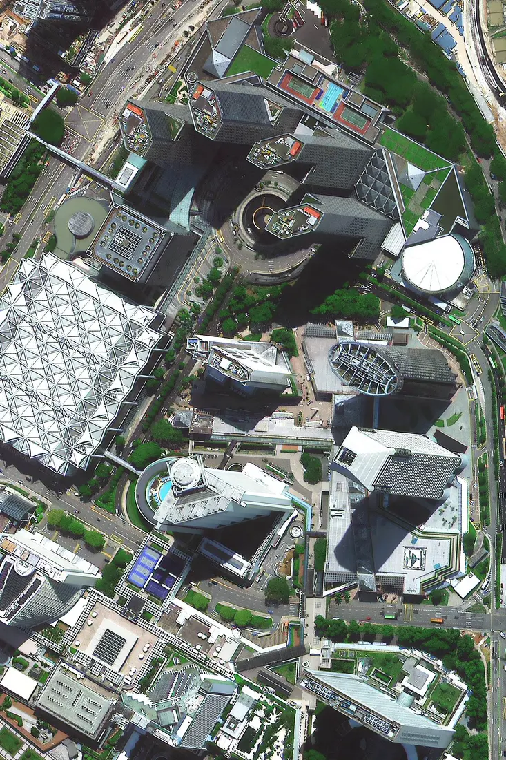
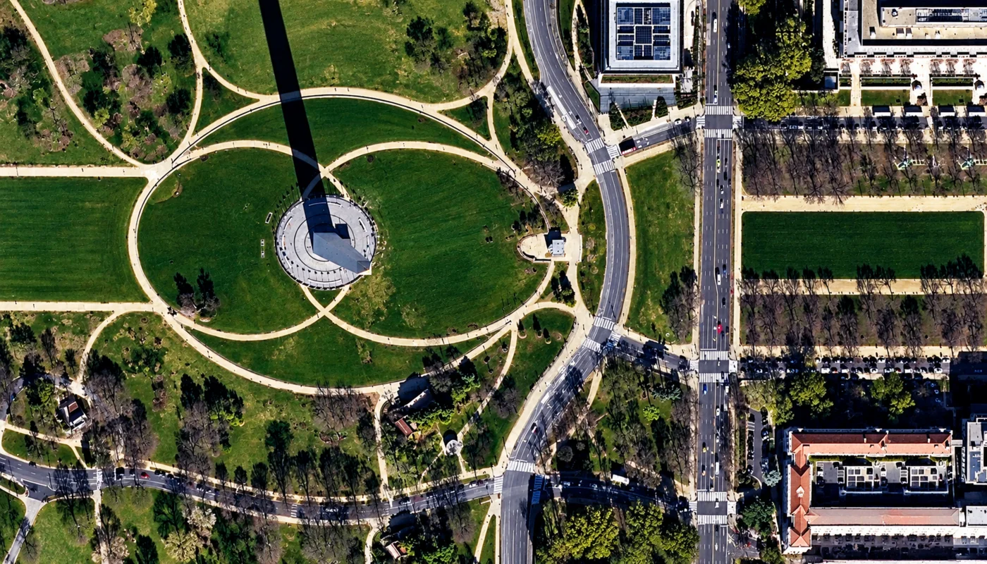
Very high-resolution optical imagery resolves individual rooflines, courtyards, and street networks across a residential district.GF-7 stereo imagery at 0.65m resolution captures planned district layouts in enough detail to support base-map updates.30cm resolution resolves individual rooftop geometry and skybridges across a dense high-rise downtown district.True top-down optical imagery resolves landmark structures, park layouts, and the surrounding street grid in one capture.ZY-3 imagery captures an entire planned mega-development, from reclaimed fronds to breakwater, in a single frame.Side-by-side change detection flags new construction between capture dates, without a site visit for every update.
Who It's For
Who Uses Urban Planning Satellite Imagery?
The same imagery and 3D data support different decisions depending on who is looking at it.
Urban & Master Planners
Build and update base maps, test zoning scenarios, and simulate development options against real 3D terrain and buildings.
Municipal & Government Agencies
Enforce zoning, detect unauthorized construction, and verify permit compliance across a city or region from one dataset.
Infrastructure & Asset Owners
Track millimeter-level deformation on bridges, rail corridors, and underground assets before it becomes a structural failure.
Smart City & GIS Teams
Feed digital twin platforms and IOC dashboards with analysis-ready 3D models, elevation data, and change layers.
Engineering & Construction Firms
Simulate build-out scenarios and monitor active sites against the as-planned design with repeat, timestamped capture.
Solutions
Satellite-Based Solutions for Urban Planning & Smart Cities
From digital twins to smart park management, satellite data and AI analytics support every stage of a city or district.
01 — SOLUTION
Digital Twins & 3D City Modeling
A city digital twin starts with turning raw satellite imagery into a geometrically accurate, building-by-building 3D base layer.
AI Building Contour Extraction: Deep learning algorithms automatically extract building outlines from high-resolution optical stereo imagery, including GF-7, SuperView-1/2, and Beijing-3A captures.
Building Regularization & Adhesion Segmentation: Edge processing simplifies redundant points and eliminates sharp angles, while height-based and co-edge algorithms separate adjacent structures that would otherwise merge into one footprint.
3D Building White Models: Top elevations and true building heights are calculated to construct simplified 3D box models, the foundational 3D base layer for digital twins, urban scenario modeling, and smart park planning.
CAD & GIS-Ready Delivery: Models are delivered as OSGB, OBJ, 3DTiles, .ifc, .fbx, and .gltf, ready to drop directly into the digital twin or BIM platform your team already uses.
02 — SOLUTION
Smart Infrastructure Deformation Monitoring
Ground movement measured in millimeters, well before it is visible on the surface, is the difference between a scheduled repair and a structural failure.
Millimeter-Level InSAR: Interferometric Synthetic Aperture Radar from C-band (GF-3) and L-band (LT-1) satellites detects subsidence and structural shifts down to 1-2mm accuracy on bridges, highways, rail corridors, buildings, and underground spaces.
All-Weather, Day-Night Coverage: Radar imaging penetrates cloud, rain, and fog, so a deformation trend does not go unmeasured during a wet season or after dark.
Real-World Precedent: This type of infrastructure deformation tracking has already been applied to monitor subsidence risk across dense urban cores such as Beijing.
Structural Risk Scoring: Deformation trends ranked across every monitored structure turn a long inspection backlog into a short, prioritized one.
03 — SOLUTION
Urban Growth, Sprawl & Land Use Regulation
A zoning master plan is only as good as a city's ability to see where it is being ignored.
AI Semantic Segmentation: Deep learning classifies land cover and land use across a region, separating residential, commercial, industrial, and undeveloped parcels automatically.
Change Detection for Enforcement: Before/after comparison flags unauthorized construction and illegal land conversion early, work a ground inspection team would otherwise have to find on foot.
Zoning Master Plan Verification: Comparing imagery against a zoning or master plan boundary confirms development is staying inside permitted limits, useful for both compliance and dispute resolution.
Regional Sprawl Tracking: Multi-year time series quantify how a city's built-up footprint has expanded, informing infrastructure and service planning ahead of demand.
04 — SOLUTION
Urban Environmental Monitoring & Smart Park Management
Air quality, green canopy, and water quality are now part of how a city is planned, not an afterthought measured once a year.
Environmental & Micro-Climate Monitoring: Fused multispectral and hyperspectral imagery tracks urban air quality, surface water pollution, green canopy vigor, and heat island effects across a city.
Smart Park Life-Cycle Management: An integrated platform covers park planning, scheme comparison, engineering construction simulation, and smart investment attraction from one dataset.
Intelligent Operations Center (IOC): A central dashboard manages 24/7 video patrols, parking guidance, equipment pre-maintenance, and energy consumption across a park or smart district.
Safety & Site Selection: The same imagery and elevation data that support planning also flag safety risks and help evaluate new sites before a lease or build decision is made.
Imagery Types
What Type of Satellite Imagery Is Best for Urban Planning?
Different sensor types answer different planning questions, and most smart city programs end up combining more than one.
Imagery Type
What It Reveals
Best For
High-Resolution Optical
Sharp, true-color detail down to individual buildings, vehicles, and rooflines
Base maps, zoning verification, construction monitoring
Stereo Optical
Paired captures from two angles, used to derive elevation and true building height
3D building white models, digital twins, terrain analysis
Multispectral
Reflectance beyond visible light, including red-edge and near-infrared bands
Green canopy health, water quality, urban heat island mapping
SAR (Radar)
All-weather, day-and-night surface structure and ground movement data
Millimeter-level InSAR deformation monitoring
DEM / DSM / DTM (Elevation)
Terrain height, surface height, and bare-ground height models
3D city modeling, drainage analysis, civil engineering
Technical Specifications
Products & Technical Specifications
Resolution tiers, elevation accuracy, and delivery formats for every urban planning product we deliver.
1m (GF-3 C-band Spotlight) and 3m (LT-1 L-band InSAR)
3D Elevation Models (DEM/DSM/DTM)
2-10m grid spacing with ±3m vertical RMSE accuracy for hydrological and civil engineering analysis
Digital Orthophoto Maps (DOM)
Pixel-aligned orthophotos at 50cm spatial resolution with 8m CE90 positional precision
Deliverable File Formats
GeoTIFF, SHP, DWG, IMG, OSGB, OBJ, 3DTiles, .ifc, .fbx, and .gltf, ready for direct GIS and CAD integration
Delivery & Platform Architecture
Cloud platform offering a 1.5-hour response time, 1-hour cloud processing and delivery, and satellite tasking uploads within 3 hours
Deliverables
The Outputs We Deliver
Every engagement includes 3D model layers, elevation and orthophoto data, and deformation and change-detection reports, not just imagery.
3D Models & Digital Twin Layers
OSGB, OBJ, 3DTiles, .ifc, .fbx, and .gltf building models ready to drop into your digital twin, BIM, or GIS platform.
Elevation & Orthophoto Data
DEM, DSM, and DTM elevation models at 2-10m grid spacing, plus 50cm pixel-aligned orthophotos, in GeoTIFF, SHP, DWG, or IMG.
Deformation & Change-Detection Reports
Millimeter-level InSAR deformation alerts and before/after change layers, ready to drop into a compliance or inspection report.
Pricing & Delivery
Urban Planning Satellite Imagery Pricing
Transparent per-km² pricing for archive and new-tasking imagery, delivered in the GIS or CAD format your team already works in. Not sure what you need? Tell us your city or site and monitoring requirement and we'll recommend the right imagery.
Standard Archive
Existing imagery, 90+ days old — ready to download within minutes
Super High Resolution (25-30cm)$20/km²
Very High Resolution (31-50cm)$13-14/km²
High Resolution (51-80cm)$5/km²
Wide-Swath (2m)$1/km²
Minimum order area 25km² per scene. Stereo imagery is priced at 2× mono, tri-stereo mapping at 3× mono.
New Satellite Tasking
Fresh capture of your exact site and date range
Super High Resolution (25-30cm)$30/km²
Very High Resolution (31-50cm)$20-22/km²
High Resolution (51-80cm)$8-10/km²
Wide-Swath (2m)$2/km²
Minimum order area 100km² per scene. Priority tasking available ahead of a planning review or permitting deadline.
Why Satellite Monitoring
Application Benefits
Faster Master Planning
AI-extracted building footprints and 3D white models replace months of manual surveying with a ready base layer.
Earlier Risk Detection
Millimeter-level InSAR deformation signals turn a potential failure into a scheduled repair.
Stronger Zoning Enforcement
Change detection flags unauthorized construction early, before it becomes a dispute or a demolition order.
Better Environmental Data
Micro-climate, green canopy, and water quality monitoring support sustainability goals with real measurements.
One Platform, Every Stage
The same satellite and AI analytics stack covers baseline survey, planning, construction, and operations.
From the Blog
Urban Planning Guides From Our Blog
More on digital twins, infrastructure monitoring, and smart city satellite data.
Tell us what you're looking for and our team will reply with options and pricing — usually within one business day.
50cm Resolution — SuperView Neo-3
See individual vehicles, crosswalks, and site detail like this, anywhere on Earth.
130+ satellites, archive and new tasking
Reply within one business day
No spam, ever
Enquiry sent
Thanks — we'll get back to you by email shortly.
Frequently Asked Questions
What is urban planning satellite imagery?
Urban planning satellite imagery is satellite-based Earth observation data, high-resolution optical, stereo, SAR, and elevation data, combined with AI analytics to build 3D city models, monitor infrastructure deformation, track urban growth and zoning compliance, and support smart city and smart park management.
How is satellite imagery used in urban planning?
Satellite imagery is used in urban planning to build digital twins and 3D building white models, monitor infrastructure deformation with InSAR, track urban growth and sprawl against zoning master plans, monitor environmental and micro-climate conditions, and manage the full life cycle of smart parks and districts. Most planning programs combine more than one of these.
How accurate is InSAR infrastructure deformation monitoring?
Interferometric Synthetic Aperture Radar (InSAR) from C-band and L-band satellites detects ground subsidence and structural shifts down to 1-2mm accuracy on bridges, highways, rail corridors, buildings, and underground spaces, with all-weather, day-and-night coverage that penetrates cloud, rain, and fog.
What is a 3D building white model and how is it made?
A 3D building white model is a simplified box-shaped 3D representation of a building, built by extracting building contours with AI from high-resolution optical stereo imagery, then calculating top elevations and true building heights. It forms the foundational 3D base layer for digital twins, urban scenario modeling, and smart park planning.
Can satellites detect unauthorized construction or zoning violations?
Yes. AI semantic segmentation and before/after change detection flag unauthorized construction and illegal land conversion by comparing repeat imagery against a zoning or master plan boundary, surfacing violations early instead of relying on a ground inspection team to find them.
What resolution do I need for an urban planning or digital twin project?
Sub-meter resolution, typically 25-50cm, is needed to extract individual building footprints and construct a city-scale 3D digital twin. Wider-area 2m imagery is enough to track regional urban growth and sprawl, where individual buildings do not need to be resolved.
What file formats are 3D city models and digital twin data delivered in?
Deliverables include GeoTIFF, SHP, DWG, and IMG for standard GIS layers, plus OSGB, OBJ, 3DTiles, .ifc, .fbx, and .gltf for 3D building models and digital twins, ready for direct GIS and CAD integration.
What is smart park life-cycle management?
Smart park life-cycle management is an integrated platform covering park planning, engineering construction simulation, smart investment attraction, and an Intelligent Operations Center managing 24/7 video patrols, parking guidance, equipment pre-maintenance, and energy consumption.
How is urban planning satellite imagery delivered and priced?
Imagery is delivered through a cloud platform with a 1.5-hour response time and 1-hour processing and delivery. Standard archive imagery starts at $1/km² for 2m wide-swath resolution up to $20/km² for 25-30cm super high resolution, while new tasking runs from $2/km² up to $30/km², with stereo imagery priced at 2× mono and tri-stereo mapping at 3× mono.
What satellites are used for urban planning and infrastructure monitoring?
Urban planning programs combine ultra-high-resolution optical satellites (SuperView Neo-1 at 25-30cm, SuperView-1/2 and Beijing-3A at 42-50cm, GF-7 and GF-2 at 65-80cm) with GF-6 wide-swath optical data, and GF-3 (C-band) and LT-1 (L-band) SAR satellites for all-weather InSAR deformation monitoring.
Ready to Build Your City's Digital Twin?
Search our live archive or request new tasking over your city or district, optical, stereo, SAR, or DEM.